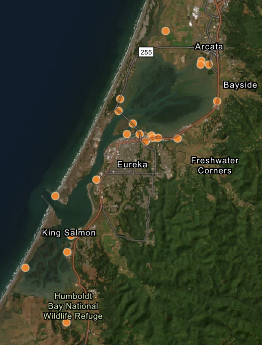
Humboldt Waterkeeper
  • About Us
    • Our Mission
    • Waterkeeper Alliance
  • Humboldt Bay
    • Geography
    • Wildlife
    • Bay Issues
    • Photo Gallery
  • Programs
    • Toxics Initiative
    • Water Quality
    • Bay Tours
    • Community Outreach
  • Get Involved
    • Report Pollution
    • Speak Out
    • Volunteer
    • Donate
    • Membership
    • Stay Informed
  • Contact Us
  • News
    • Latest
    • Press

Sea Level Rise

The Humboldt Bay area is experiencing the fastest rate of relative sea level rise on the West Coast. That's because tectonic activity is causing the ground beneath the bay to sink at the same rate that the ocean is rising. According to the California Ocean Protection Council's 2024 Science & Policy Update, sea level in the Humboldt Bay area is expected to rise approximately 1.5-2 feet above 2000 levels by 2060 and 3.9-5.5 feet by 2100. 
The primary impacts from sea level rise are increases in flooding, erosion, and rising groundwater. Sea level rise will expand areas vulnerable to flooding during major storms, as well as in the rare but catastrophic event of a major tsunami. The term 100-year flood is used as a standard for planning, insurance, and environmental analysis. But these extreme storms are happening with increasing frequency, in part due to rising seas. Sea level rise will cause more frequent—and more damaging—floods to those already at risk and will increase the size of the coastal floodplain, placing new areas at risk to flooding. To view sea level rise scenarios for the Humboldt Bay area, visit NOAA's 2022 Sea Level Rise Viewer and go to the local scenario for the North Spit. 
NEW! Now you check out our interactive map of two sea level rise scenarios for the Humboldt Bay Area! Featured are scenarios showing 1- and 2-meters above Year 2000 water levels. For many years, these have been static maps with no simple way for the public to examine points of interest. Now, people wondering if their neighborhood is at risk can zoom in on locations and see street names, etc. 


California King Tide Photo Gallery — and how to submit yours!

Details
Jennifer Kalt
King Tide Photo Initiative
17 January 2026
Created: 17 January 2026
Screen shot of photo gallery.The California Coastal Commission's King Tide Photo Project features photos from the Humboldt Bay area and across the state. Anyone can upload photos online or via a smartphone app. Click HERE to upload yours. You can check out King Tide photos from across the state at this interactive photo gallery.
Wondering about good spots to view the King Tides around Humboldt Bay? Visit our Humboldt Bay King Tide Photo Project.

Stormy King Tides, January 2-3, 2026

Details
Jennifer Kalt
King Tide Photo Initiative
31 December 2025
Created: 31 December 2025
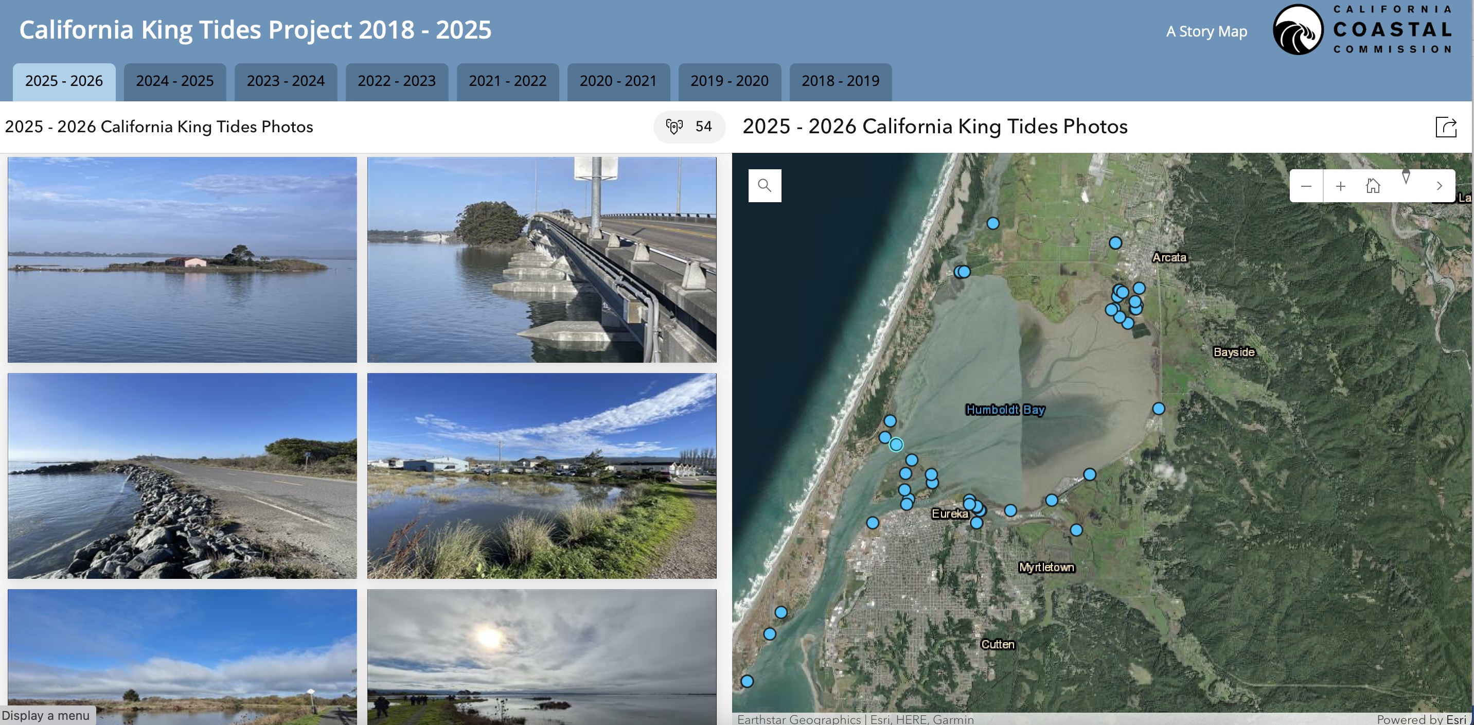
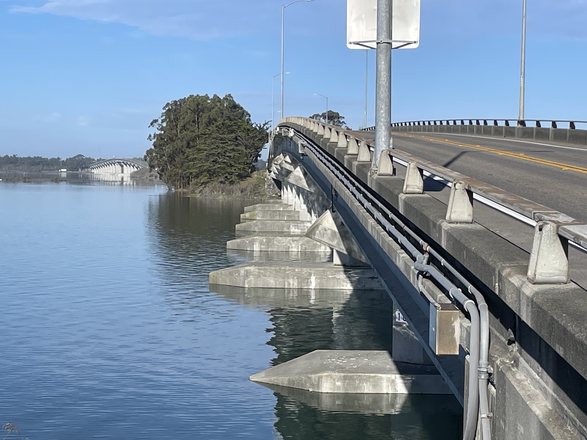
This winter's last set of King Tides will arrive this Friday and Saturday, January 2-3. The current tides are nearly a foot higher than predicted, and with more rain in the forecast and winds from the south, these tides are likely to be even higher than they were in early December. 
BE EXTREMELY CAUTIOUS when viewing these King Tides! Under these conditions, you may encounter eroding shorelines, rapidly rising water, and flooded roadways. With recent storms, the ground is so saturated that in low-lying areas, there's nowhere for more stormwater runoff to go. As always, wear bright colors so drivers can see you, and never drive through flooded roadways. Photo of the Samoa Bridges on Dec. 4, 2025 by J. Kalt.
Read more …

King Tide Photo Initiative: December 4-6, 2025

Details
Jennifer Kalt
King Tide Photo Initiative
02 December 2025
Created: 02 December 2025
The highest tides of this winter (known as King Tides) are predicted this Thursday, Friday, and Saturday, December 4-6. To get involved, all you need is a camera or a smartphone. You can upload your photos to the California King Tide Photo Project, which is a great opportunity to contribute to a long-term dataset, while helping inform residents and decision makers about the need to plan for the coming changes to our natural and built environments.
Please USE EXTREME CAUTION when viewing the King Tides! Wear bright colors near roads and be very cautious of rising water, eroding shorelines, and flooded roadways. Tides may be much higher than predicted depending on wind, rain, etc.
Read more …

King Tide Photo Initiative: January 20-21, 2023

Details
Jennifer Kalt
King Tide Photo Initiative
16 January 2023
Created: 16 January 2023
NewNavyBaseRd12 24 22The highest tides of this winter (known as King Tides) are predicted on Friday & Saturday, January 20-21. 

These tides may be much higher than predicted
due to the southerly winds and Eckman Transport, which piles water up along our coast. Please USE EXTREME CAUTION when viewing the King Tides! And remember to wear bright colors so drivers can see you. 
To get involved, all you need is a camera or a smartphone. Submit your photos to This email address is being protected from spambots. You need JavaScript enabled to view it. or upload them to the California King Tide Photo Project.
Photo: Erosion along New Navy Base Road in Samoa dislodged a PG&E vault during the December 23-24 King Tides.
Read more …

King Tide Photo Initiative: Dec. 23, 2022 & Jan 21, 2023

Details
Jennifer Kalt
King Tide Photo Initiative
19 December 2022
Created: 19 December 2022
King Tides are coming on Friday, Dec. 23 & Saturday, Jan. 21. To get involved, all you need is a camera or a smartphone. Submit your photos to This email address is being protected from spambots. You need JavaScript enabled to view it..
Photo: Waves crash over the South I Street parking lot  and boat ramp at the Arcata Marsh, Jan. 3, 2022. Photo by Kristen Orth-Gardinier.
Read more …

More Articles …

  1. 2021-22 King Tides Photos
  2. King Tides Photo Initiative: Focus on the old railroad, December 4 & 5
  3. King Tide Photo Initiative: January 11 & 12, 2021
  4. Sea Level Rise and King Tides at Eureka Slough

In the News

King Tide Photo Initiative

  • Start
  • Prev
  • 11
  • 12
  • 13
  • 14
  • 15
  • 16
  • 17
  • 18
  • 19
  • 20
  • Next
  • End

Advanced Search

Current Projects

  • Mercury in Local Fish & Shellfish
  • Nordic Aquafarms
  • Offshore Wind Energy
  • Sea Level Rise
  • 101 Corridor
  • Billboards on the Bay
  • Dredging
  • Advocacy in Action
  • Our Supporters
Report A Spill
California Coastkeeper
Waterkeeper Alliance
Copyright © 2026 Humboldt Waterkeeper. All Rights Reserved.